Friday, 10 .June, 2005, 17:29 -
English Entries,
Travel,
TechnologyI bought the Nokia LD-1W GPS receiver a while ago, in order to keep track of my cycle trips. The device itself is pretty easy, it receives GPS data and cannot store them itself. So one needs to connect a mobile phone via Bluetooth to it and on that phone needs to be an application running that is able to receive the GPS data.

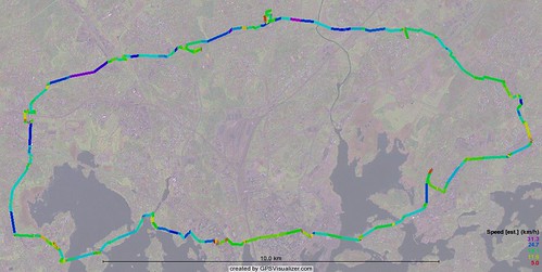
Trip done today by bike through Helsinki
Recorded with PowerNavigation 2
Visualization by gpsvisualizer.com
I am not really interested in a navigation system, i.e. in a software that shows me how i get from A to B. Although that would be nice to have, it is too complex and is also very expensive. All I want is to see where I went and how fast I was.
The whole business of keeping track and putting the routes finally on maps is everything else but trivial and I am already several days hanging over the devices and different PC applications to get something out of it.
There are several applications for the phone type I have, that can connect to a GPS receiver. Of all of them I first thought AFTrack as useful, as it can store the track (i.e. the route that is drive/cycled/walked) in the IGC format, which is a standardized format. Yes, AFTrack can do that, but most of the time it suddenly stoped when I moved. So it looks perfectly working for a while and then - sssssddd - disappears. Thank you, that is not useful.
Some days ago I found now PowerNavigation 2 - this tool is keeping track reliably. So this is now running on my Series60 mobile.
Next step is to get the route on maps. There is no easy way for that. Some programs allow scanning of maps and calibrating them to the latitudes / longitudes that are drawn on it. The OziExplorer is such a program, it really works fine, but the scanning of maps is a nightmare. I tried it and it all works fine as long as I have only one piece of a map. But usually I want a whole map scanned and as my scanner is not big enough I need to break down the map into pieces (tiles). I tried to combine these scanned tiles to a big map on the PC - I used several graphics programs and also specialized programs for this purpose. It simply does not work, most likely I am too stupid.
But there is a nice online tool, the GPS visualizer. It has basic maps, which seem to be made from satellite photographs. These maps do not contain any city names or whatsoever legend, but still they give a basic backround for the covered distance.

Trip (by car) from Quebec to Montreal
This all seems to be a science on its own. If somebody here knows more about such tools or how to use them more efficiently, I would be happy to read about it.


 The last two weeks were so sunny and beautiful in Helsinki that it was not possible to spend more time than really needed in front of the computer. A month ago it was still all ice and grey here and now the sun is already hesitating till 22.00 until it vanishes for a few hours and the birch trees in the backyard are green.